COVID-19 Spatio-temporal case-density map
This web-application visualizes the spatio-temporal spread of the outbreak of a novel corona infectious disease (COVID-19) over Japan. The location of the COVID-19 outbreaks in this spatio-temporal map was obtained from voluntary information on outbreaks in facilities such as commercial facilities, restaurants, hospitals and offices (according to JX Press Corporation) while the vertical axis represents time of the outbreaks. The space-time kernel density tool was used for creating this app. (Award Winning: first place of Analytic Method and Results & first place of most innovative map, the 2021 Esri User Conference)

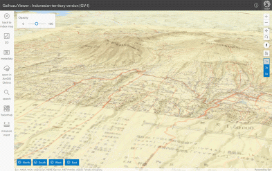
Gaihozu Viewer for the Indonesian Territory: Browsing Georeferenced Old Military Maps from the Collection of Gaihozu at Tohoku University. (Award Winning: third place of 3D map, the 2021 Esri User Conference)
Gaihozu (Historical Military Maps of Former Japanese Imperial Army) Index Map Search (in Japanese): A WebGIS-based Interface of the Gaihozu Digital Archive.

Comparative Interactive Maps of Walkability Score and Area Deprivation Index in Japan, 2010.

3D Hazard Map of Hisorical City, Kyoto (developed at DMUCH, Ritsumeikan University).
